Paddle SC
Camping Fee Required Handicap Accesible Parking- Dedicated Lot Roadside Parking Restrooms / Toilets

North Tyger River: Highway 221 (Unofficial) to Morris Bridge Road (Unofficial)

Scroll down for more details
Legend
Hide All

North Tyger River: Highway 221 (Unofficial) to Morris Bridge Road (Unofficial)

Skill Level: Moderate
Loading 
Rapids: Class I , II
Length: 3.60 miles
Duration: 2 - 2.5 hours
Portaging: No
What to Expect

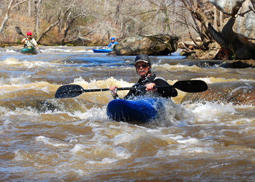
This section is on the North Tyger River and includes many curves in the river, and includes some exciting shoals/rapids. There is a high potential for wood and debris strainers along this stretch.

Access
Put in:
Highway 221 River Access (Unofficial)
 6304 US 221, Roebuck, SC 29376
Access Details

The river access at Highway 221, near the intersection of Highway 221 and Interstate 26, can be  used as a take-out (from Anderson Mill) or a put-in (trip to Morris Bridge Road). There is no parking available at this river access.

Take out:
Morris Bridge Road River Access and Roadside Parking (Unofficial)
 1760 Morris Bridge Road, Roebuck SC
Access Details

Limited parking and river access is available where Hobbysville Road curves left and turns into Morris Bridge Road, before the bridge. Park north-west of the road, river-right, on the road's shoulder and follow the worn path on upstream right, which leads down the hill to the river. Please pull cars completely off the road and be aware of other vehicles. 

Trip Details

This trip begins near the Highway 221 /Interstate-26 interchange on the North Tyger River. Morris Bridge Road is a 10 minute drive from Highway 221; shuttling cars could take about half an hour. River access at Highway 221 is upstream of the bridge, river left. Limited roadside parking is available along Frontage Road. Follow the power line right of way to the river. Once on the river, there is not another road crossing until nearing the take out. About 1.9 miles before the I-26 bridge, paddlers will encounter "Ott Shoals", a set of Class I-II rapids along a 400 foot island. Paddlers should stay to the left/larger channel. After the shoals, the I-26 bridge is 1.7 miles downstream. After crossing under the I-26 bridge, which is a pair of two bridges, the take out is approximately 1,300 feet downstream. Take out before the Morris Bridge Road bridge (S-231), river left. For more information see the Tyger River Blueway map.

Waterway: 

Comments (1)

Please Sign In or Create Account to add your photo to this trip
James Moss
Aug 10, 2018 10:47 am EDT
A friend and I kayaked this run on 09Aug2018 when the flow was at around 350cfs. Just wanted to give a heads up to anyone thinking about doing this route, that there are trees across the river for the first mile or so. This is upstream of the old hydro location. We had to go over/under/around trees ever 50-100 yards. We should have taken a saw and machette. We realize that 350cfs is below the runnable limit, but around here it rarely gets in that runnable window, so you deal with whatever happens. We will not be doing this route again any time soon due to the trees. The next leg downstream is always a good one for us, even when the water is low.
Please Sign In or Create Account to add your photo to this trip
paddling above Morris Bridge Road
Trip Resources
River Flow (CFS)
Discharge flow information
CURRENT CFS
Flows for safe padding (cfs)
MINIMUM
550
MAXIMUM
1000
X Close
Skill Level
Easy
Moderate
Difficult
Advanced
Learn more
X Close
Flow Level
Runnable
Above Runnable
Below Runnable
No Information
Learn more
X Close
Skill & Flow Level
Easy
Moderate
Difficult
Advanced
Runnable
Above Runnable
Below Runnable
No Information
X Close
Access Amenities
Parking - Dedicated Lot
Parking - Roadside
Restroom / Toilets
Fee Required
Handicap Accessible
Camping
Paddle SC is presented by
Upstate Forever
South Carolina Department of Natural Resources
South Carolina National Heritage Corridor
Rainey Foundation