Paddle SC
Camping Fee Required Handicap Accesible Parking- Dedicated Lot Roadside Parking Restrooms / Toilets

Enoree River: Jones Ford Road (Unofficial) to Forest Service 336A Landing

Scroll down for more details
Legend
Hide All

Enoree River: Jones Ford Road (Unofficial) to Forest Service 336A Landing

Skill Level: Easy
Loading 
Rapids: None
Length: 11.60 miles
Duration: 6 - 6.5 hours
Portaging: No
What to Expect

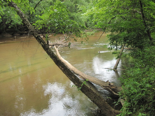
The Enoree River enters the Sumter National Forest during this trip, providing an extremely rural wilderness feel. Paddlers will see densely wooded forests along the river banks, wildlife, and little to no evidence of human influence along the way. This is a long trip and can take around 6-6.5 hours. During lower water, paddlers will need to navigate around shallow sand bars and fallen trees. This trip can be combined with other sections for excellent overnight and weekend camping trips. 

Access
Put in:
Jones Ford Road River Access and Roadside Parking (Unofficial)
 1398 Jones Ford Road
Access Details

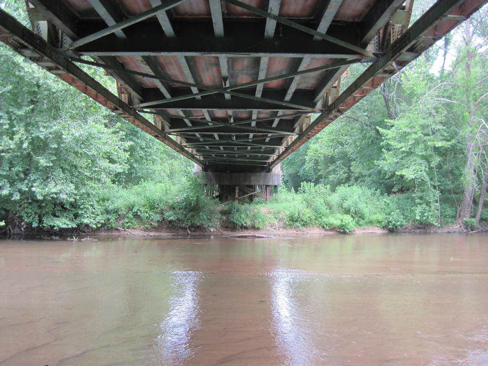
This river access is located downstream of Barrel Stave Road/Jones Bridge Road, river-right. Park along the road's shoulder. A short trail leads from the road to the river underneath the bridge. This access is unofficial; use at your own risk. Click HERE for more information. 

Take out:
Forest Service 336A Landing River Access and Parking Area
 FSR 336 A Road, Whitmire, SC 29178
Access Details

The Forest Service 336A Landing is not well marked from the river, and the banks can be steep depending on water levels. From Ridge Road, turn north on FS 336B Road; go 0.1 miles and turn right onto FS 336; in 0.5 miles, turn left onto FS 336A and the landing will be 1.7 miles ahead. A short trail leads from the parking area to the river bank (river-right). Visit the Forest Service for more information.

Trip Details

The take out is 25 minutes away from the put in, so shuttling cars could take close to an hour. Once on the river, paddlers will experience flatwater with no road crossings. The take out is not well marked from the river, so a GPS unit may assist in navigation. The take out is river-right.

Waterway: 

Comments (2)

Please Sign In or Create Account to add your photo to this trip
Shane Cropper
Jan 22, 2023 3:57 pm EST
Start (part 1/4) of a weekend kayak/camping trip that ended at Keitts Bridge. CFS was around 400. Put in: A little sketchy with about a 3 foot drop from the bank to the water. The water itself was 1-2 feet deep so aside from getting wet it was easy to get in the kayak. Skill Level: Lots of trees in the water that did require some skill at the high end of easy or low moderate but no portages. Take Out: I completely missed it so be very careful if you need to take out at Forest Service 336A Landing. Wildlife: Lots of birds including ducks and geese. Something in the water intentionally took a beeline, dove under my kayak and bumped it pretty hard. (Otter? Beaver? Muskrat?). Heard coyotes and owls all night long while camping. Camping: At this water level there were only selected places to leave the river. The easiest were the relatively frequent sandbars. Provided you could get off the river there were plenty of great sites. Overall: Did not see a single additional person during this entire trip. Great for someone comfortable in the water that does not mind navigating around the frequent trees and that wants to get away for a few hours or a weekend. Be careful with the takeout as I missed it.
Shane Cropper
Jan 22, 2023 3:56 pm EST
Start (part 1/4) of a weekend kayak/camping trip that ended at Keitts Bridge. CFS was around 400. Put in: A little sketchy with about a 3 foot drop from the bank to the water. The water itself was 1-2 feet deep so aside from getting wet it was easy to get in the kayak. Skill Level: Lots of trees in the water that did require some skill at the high end of easy or low moderate but no portages. Take Out: I completely missed it so be very careful if you need to take out at Forest Service 336A Landing. Wildlife: Lots of birds including ducks and geese. Something in the water intentionally took a beeline, dove under my kayak and bumped it pretty hard. (Otter? Beaver? Muskrat?). Heard coyotes and owls all night long while camping. Camping: At this water level there were only selected places to leave the river. The easiest were the relatively frequent sandbars. Provided you could get off the river there were plenty of great sites. Overall: Did not see a single additional person during this entire trip. Great for someone comfortable in the water that does not mind navigating around the frequent trees and that wants to get away for a few hours or a weekend. Be careful with the takeout as I missed it.
Please Sign In or Create Account to add your photo to this trip
Enoree River below Jones Ford Road (Credit: Upstate Forever)
Enoree River at FS 336A (Credit: Upstate Forever)
Trip Resources
Download map files for your own use. Learn more
River Flow (CFS)
Discharge flow information
CURRENT CFS
Flows for safe padding (cfs)
MINIMUM
250
MAXIMUM
1500
X Close
Skill Level
Easy
Moderate
Difficult
Advanced
Learn more
X Close
Flow Level
Runnable
Above Runnable
Below Runnable
No Information
Learn more
X Close
Skill & Flow Level
Easy
Moderate
Difficult
Advanced
Runnable
Above Runnable
Below Runnable
No Information
X Close
Access Amenities
Parking - Dedicated Lot
Parking - Roadside
Restroom / Toilets
Fee Required
Handicap Accessible
Camping
Paddle SC is presented by
Upstate Forever
South Carolina Department of Natural Resources
South Carolina National Heritage Corridor
Rainey Foundation