Paddle SC
Camping Fee Required Handicap Accesible Parking- Dedicated Lot Roadside Parking Restrooms / Toilets

Chattooga River: Section 2

Scroll down for more details
Legend
Hide All

Chattooga River: Section 2

Skill Level: Moderate
Loading 
Rapids: Class I , II
Length: 7.00 miles
Duration: 2 - 3 hours
Portaging: No
What to Expect

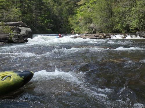
Experience the beauty of the Wild and Scenic Chattooga River. Section 2 is a good beginner whitewater section with class I and II rapids. 

Access
Put in:
Highway 28 Access
Access Details

About 1.5 miles before crossing the Chattooga River into Georgia, the Highway 28 River Access is on the left. 

Take out:
Earls Ford Access
Access Details

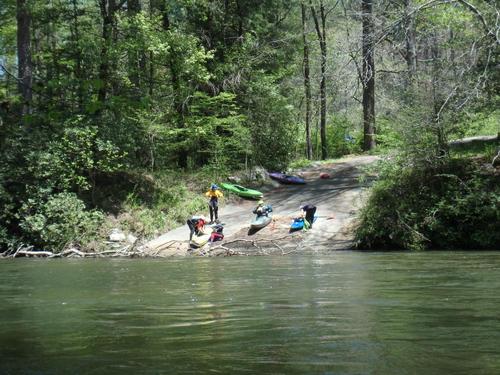
Earls Ford has a trailhead, river access, and camping access. When taking out at Earls Ford, look for two trails at the rocky beach area. The downstream trail is the one that leads to the parking lot. 

Trip Details

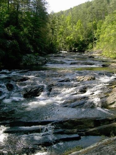
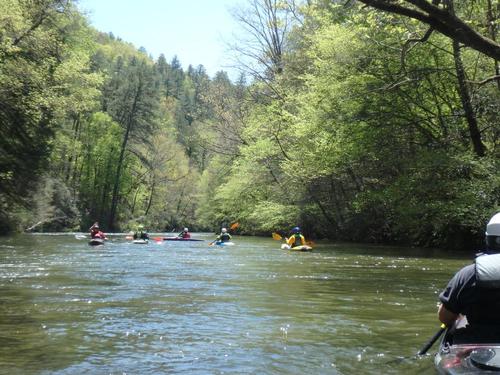
This section of the Chattooga lets more novice paddlers experience the wild and scenic beauty of the Chattooga. Class I and II rapids are dispersed among big, deep pools of crystal clear water. This 7 mile run is a good day trip with opportunities to stop and picnic on large boulders, or stop to fish for trout. The Chattooga has excellent opportunities for fishing, camping, and hiking.

The Chattooga, a designated National Wild and Scenic River, is recognized as one of the Southeast's premier whitewater rivers, dropping almost 1/2-mile in elevation from the headwaters in North Carolina. The river is one of the few remaining free-flowing streams (there are no dams along its course) in the Southeast. The Chattooga offers outstanding scenery, ranging from thundering falls and twisting rock-choked channels to narrow, cliff-enclosed deep pools. The setting is primitive; dense forests and undeveloped shorelines characterize the primitive nature of the area. 

Waterway: 

Comments (3)

Please Sign In or Create Account to add your photo to this trip
Shane Miller
Jul 06, 2023 1:33 pm EDT
I am new to planning a Kayak trip. I am looking for a good river to go to mid Sept for a 4 day adventure. not sure how the water levels are affected after a summer. any suggestions?
Paula Cumalander
Feb 27, 2023 4:35 pm EST
2018 Showing drop at Big Shoals. We ran the river left channel. Enter just left of the big rock (right side of the rapid) then cut left to avoid rocks at the bottom. .https://youtu.be/uX0p3Mk2ffE
Krzysztof Zaryczny
Aug 10, 2020 11:18 am EDT
Paddled this section on 7/5/20. The flow was 1.69 ft. which was fine. Not sure how 1.5 would be. There were a few nice little rapids where water would splash inside the kayak. Big Shoals was fun. We stayed on river right (river left has a large tree down) and went through the right channel on left part which had the best flow. You can portage easily over the shoal which we saw someone do with their canoe. Nice river, but the long take out uphill is NOT fun. Would recommend a backpack / wheels to help get your gear back to the parking lot.
Please Sign In or Create Account to add your photo to this trip
(Credit: Upstate Forever)
Put- in (Credit: pcumalander-frick)
View on the river (Credit: pcumalander-frick)
Big Shoals Rapid (Credit: pcumalander-frick)
Trip Resources
Download map files for your own use. Learn more
River Flow (FT)
Discharge flow information
CURRENT FT
Flows for safe padding (ft)
MINIMUM
1.5
MAXIMUM
5
X Close
Skill Level
Easy
Moderate
Difficult
Advanced
Learn more
X Close
Flow Level
Runnable
Above Runnable
Below Runnable
No Information
Learn more
X Close
Skill & Flow Level
Easy
Moderate
Difficult
Advanced
Runnable
Above Runnable
Below Runnable
No Information
X Close
Access Amenities
Parking - Dedicated Lot
Parking - Roadside
Restroom / Toilets
Fee Required
Handicap Accessible
Camping
Paddle SC is presented by
Upstate Forever
South Carolina Department of Natural Resources
South Carolina National Heritage Corridor
Rainey Foundation