Paddle SC
Camping Fee Required Handicap Accesible Parking- Dedicated Lot Roadside Parking Restrooms / Toilets

Wambaw Creek: Elmwood Landing to Still Landing

Scroll down for more details
Legend
Hide All

Wambaw Creek: Elmwood Landing to Still Landing

Skill Level: Easy
Flow Level No Information
Rapids: None
Length: 4.00 miles
Duration: 2 - 3 hours
Portaging: No
What to Expect

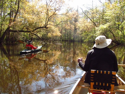
Wambaw Creek is a black water tidal creek located in the Francis Marion National Forest. It meanders through the Wambaw Creek Wilderness Area created in 1980. This trip can be run either upstream or downstream using the tide direction.

Access
Put in:
Elmwood Landing
 Forest Road 204 next to bridge
Access Details

Parking on road leading to landing.

Take out:
Still Landing
 Forest Service Road 211-b
Access Details

Landing is gravel rock with no restrooms.

Trip Details

Located entirely within the boundaries of the National Forest, wildlife is abundant along the Wambaw Creek. The area is heavily populated with whitetail deer. The illusive Carolina panther and black bear have also been sighted along the trail. A quiet paddler will greatly increase his odds for sighting some of the abundant wildlife. The primary growth on the higher ground is loblolly pine, and cypress is the predominate growth along the creek. Many of the cypress trees along the banks are quite large and were there when Brigadier General Francis Marion and his Brigade roamed the area terrorizing the entire British Army in South Carolina. Francis Marion and his troops would then vanish ghost-like into these swamps, explaining Marion’s well-known nickname of “The Swamp Fox.”

It is important to remember that the Wambaw Creek is tidal, so planning your trip to coincide with the tidal flow will make the trip easier. For those desiring an overnight adventure, primitive camping is permitted at Elmwood Landing.

In the 1700s, settlers used slave labor to convert parts of this swamp into rice fields and harvest timber and you can still see remains of long-abandoned canals and rice-field dikes along the way. Although the surrounding land is a dull loblolly pine forest (large timber companies took most mature trees by the 1930s), there’s a chance you may see rare swallow-tailed kite, black-crowned night heron, and red-shouldered hawk.

This paddling trip brought to you by Berkeley Blueways.

Waterway: 

Comments (3)

Please Sign In or Create Account to add your photo to this trip
steve son
Oct 05, 2020 10:50 pm EDT
Kathie Livingston
Mar 14, 2018 7:25 am EDT
Because it's a wilderness area groups are limited to 12.
Kathie Livingston
Mar 14, 2018 7:11 am EDT
This is a pristine, protectrd wilderness area and there is another 4.5 miles further up you can paddle past still landing if heading north or snot her 2.2 Mile's downstream to the Santee River. With the tide chart listed here plan on a 45 minute lag past the time. If you need a kayak or canoe NatureAdventuresOutfitters.com offers rentals and Naturalist guided tours twice a day there! 843-697-2075. They are the Only permitted outfitter locally based and have been offering these services for over 20 years. .
Please Sign In or Create Account to add your photo to this trip
Trip Resources
Download map files for your own use. Learn more
Today's Tides
X Close
Skill Level
Easy
Moderate
Difficult
Advanced
Learn more
X Close
Flow Level
Runnable
Above Runnable
Below Runnable
No Information
Learn more
X Close
Skill & Flow Level
Easy
Moderate
Difficult
Advanced
Runnable
Above Runnable
Below Runnable
No Information
X Close
Access Amenities
Parking - Dedicated Lot
Parking - Roadside
Restroom / Toilets
Fee Required
Handicap Accessible
Camping
Paddle SC is presented by
Upstate Forever
South Carolina Department of Natural Resources
South Carolina National Heritage Corridor
Rainey Foundation